Event research High Water
High Water tickets are on sale right now.
Are High Water tickets likely to be profitable in North Charleston, SC?
There are 0 presales for this event.
High Water
Riverfront Park
North Charleston, SC
Apr 20 Sat • 2024 to Apr 21 Sun • 2024
Festivals | Undefined | Alternative | Folk | Alternative Rock | Rock and Pop | Jazz and Blues | More Concerts | Ballet and Dance | Competitions | Event | Rock | World Music | More Miscellaneous | Country and Folk | R&B/Urban Soul | R&BAi Ticket Reselling Prediction
Sign Up to get artificial intelligence powered ticket reselling predictions!
Using artificial intelligence, concert attendance stats, and completed sales history for ticket prices on secondary market sites like Stubhub, we can predict whether this event is hot for resale. The Ai also considers factors like what music genre, and what market the concert is in.
Shazam is a music app that helps you identify the music playing around you. The more times an artist gets Shazamed, the higher this score will be, which should give you an idea of the popularity of this artist. Scores are ranked on a scale of 1 to 5. Learn more
Google Trends shows how popular a search query is for an artist. The more popular the artist is and the more people that are Googling them, the higher this score will be. Scores are ranked on a scale of 1 to 5. Learn more
52,952
Capacity
High Water at the Riverfront Park, North Charleston, SC
Tour Schedule
High Water
335 similar events found
Watch on YouTube
Listen on iTunes
Wikipedia Bio


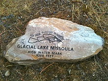
A high water mark is a point that represents the maximum rise of a body of water over land. Such a mark is often the result of a flood, but high water marks may reflect an all-time high, an annual high (highest level to which water rose that year) or the high point for some other division of time. Knowledge of the high water mark for an area is useful in managing the development of that area, particularly in making preparations for flood surges.[1] High water marks from floods have been measured for planning purposes since at least as far back as the civilizations of ancient Egypt.[2] It is a common practice to create a physical marker indicating one or more of the highest water marks for an area, usually with a line at the level to which the water rose, and a notation of the date on which this high water mark was set. This may be a free-standing flood level sign or other marker, or it may be affixed to a building or other structure that was standing at the time of the flood that set the mark.[3]
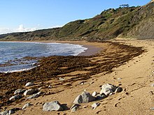
A high water mark is not necessarily an actual physical mark,[4] but it is possible for water rising to a high point to leave a lasting physical impression such as floodwater staining. A landscape marking left by the high water mark of ordinary tidal action may be called a strandline and is typically composed of debris left by high tide. The area at the top of a beach where debris is deposited is an example of this phenomenon. Where there are tides, this line is formed by the highest position of the tide, and moves up and down the beach on a fortnightly cycle.[5] The debris is chiefly composed of rotting seaweed, but can also include a large amount of litter, either from ships at sea or from sewage outflows.[6]
- ^ J. Curtis Weaver and Thomas J. Zembrzuski, Jr., "August 31, 1993, Storm Surge and Flood of Hurricane Emily on Hatteras Island, North Carolina", in Charles A. Perry, L. J. Combs, Summary of floods in the United States, January 1992 through September 1993 (1995), U.S. Geological Survey Water-Supply Paper 2499, p. 260, stating: Documentation of notable coastal floods provides scientists and flood-plain managers with useful data and technical information for an improved understanding of the hazard and for improved management of flood-prone areas. Of particular importance is documentation of the duration of flooding (and rates of rise and recession of floodwaters), maximum flood elevations and depths, and delineation of the extent of storm-surge flooding.
- ^ Daniel Kahneman, Thinking, Fast and Slow (2011), p. 137.
- ^ Nancy McTigue, James M. Symons, The Water Dictionary: A Comprehensive Reference of Water Terminology (2011), p. 284.
- ^ Bruce S. Flushman, Water Boundaries: Demystifying Land Boundaries Adjacent to Tidal Or Navigable Waters (2001), p. 73.
- ^ "Strandline" (PDF). Durham Biodiversity Partnership.
- ^ "Strandlliines" (PDF). North Cornwall District Council. Archived from the original (PDF) on 2007-10-18.
Source: Wikipedia

